The New South Wales Government today launched the NSW Spatial Digital Twin, a digital representation of 8,500 square kilometres in Western Sydney.
The virtual environment is one of largest of its type, according to the NSW Government. It includes more than half a million buildings, 20,000 km of roads, 22 million trees and 7,000 strata plans.
Users can visualise various data sets, including the state’s digital cadastre (land records), administrative boundaries, elevation and depth data, property sales and valuations, Building Information Modeling (BIM) data, and real-time data about trains, buses and air quality.
They can view some of this in 3D, and see how the view has changed over time - a feature called 4D. For example, users can compare aerial imagery of Western Sydney from the 1940s with recent images of the same locations.
Anyone can use a web browser to view the virtual environment, though authorised users can log-in for access to additional data sets.
The virtual environment will initially “support” the Blue Mountains, Camden, Campbelltown, Fairfield, Hawkesbury, Liverpool, Penrith and Wollondilly. The NSW Government hopes to expand it to encompass other areas.
The NSW Government sees the tool enabling better planning of roads and buildings. It is also touting it as a way for the public to see what projects will look like before they’re built.
“A picture paints a thousand words – being able to visualise a project before it starts means we can plan for and predict future outcomes,” stated Víctor Dominello, Minister for Customer Service.
The NSW Government is also positioning the digital twin as a business tool. For example, a developer could use it to see where utilities’ pipes are or how a building might affect surrounding infrastructure. Businesses can download the digital twin data or use an API to consume it.
One business that’s collaborating with the NSW Government on digital twins is Lendlease. It is working on sharing data to help first responders access buildings during emergencies.
Combining data
A significant aspect of the project is its combination of a wide range of data.
The digital twin's foundation is three-dimensional aerial imagery, LiDAR and cadastre data. It also connects to data portals run by Transport for NSW, NSW Department of Primary Industries and Data.NSW.
NSW Spatial Services brought together the data, while the CSIRO’s Data 61 worked to visualise it. Data61 used its open source MAGDA data catalogue and TerriaJS geospatial data publication framework to combine public and private sector data and build the digital twin.
Additional data sources include utilities and telecommunication companies, and BIM data about a train station and bus station.
NSW Spatial Services also hopes to incorporate data from Internet of Things (IoT) networks operated by councils.
Mats Henrikson, Geospatial Web Systems Group Leader at Data61, sees potential for more IoT systems to connect to the digital twin.
"Cities have never been so data rich as a result of connected sensors and many are growing vertically in addition to horizontally. This creates incredible opportunities to overlay 3D/4D data from satellite and drone technologies which is spatially accurate, to show the bigger picture of what’s happening above and below the ground over time,” Henrikson stated.
The Victorian Department for Environment, Land Water and Planning (DELWP) is also building a digital twin, which will represent around 485 hectares in the Fishermans Bend renewal area near the Melbourne CBD. DELWP is working with The University of Melbourne on the project.
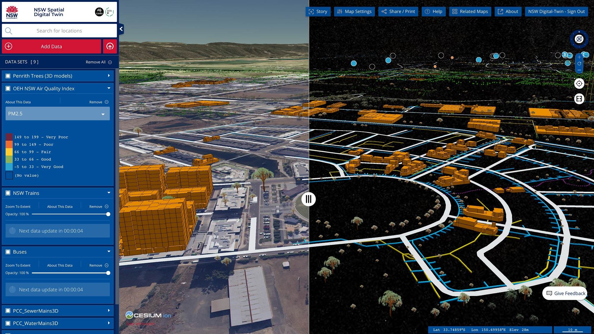
A NSW Spatial Digital Twin screeenshot, showing the location of trees, air quality readings, and the location of buses, trains and sewage infrastructure in Penrith. Click to enlarge.